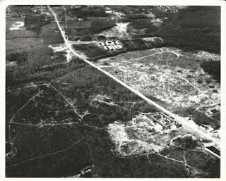
Asbury Circle - Early 1960's (Looking Southeast)
Asbury Circle - Wanamassa - Colonial Terrace 1960's (From Overhead)
Appleby Drive on right (Looking East)
Wanamassa- Radio Tower and Industrial Park left -
Sunset Avenue bottom - Route 35 right (Looking Northwest)
Wayside - Route 35 lower right - Asbury Avenue and Asbury Circle
lower left - Bowne Road upper (Looking Northwest)
Wayside - Bowne Road right - Cold Indian Springs Road middle -
Route 35 upper left - Asbury Avenue upper right (Looking Southeast)
Wayside - Bowne Road right - Deal Road Bottom -
Cold Indian Springs Road upper (Looking South)
Parkway upper left (Looking north)
Cold Indian Springs left - Route 35 and Middlebrook
Apartments right (Lookin North)
Poplar Road/Roller Road left (Looking South)
Cold Indian Springs Road lower left (Looking North)
in the 1950's (Looking Northeast)
early 1960's (Middlebrook Apartments just started)
Asbury Park and Ocean upper (Looking Southeast)
(Dwight Drive and Middlebrook not yet started) (Looking South)
Middlebrook just started (Looking Northeast)
Middlebrook just started (Looking Southbound)
Wanamassa - Route 35 at Deal Road mid-1960's
(Middlebrook Apartment built, shopping
center not started (Looking South)
Wayside - Middlebrook Apartments - Deal Road upper right -
Route 35 lower right - mid-1960's
Wayside - Route 35 at Deal Road mid-1960's
Wayside - Deal Road - Poplar Road/Roller Road upper -
(Middlebrook Apartment built, shopping
center not started (Looking Northwest)
(Middlebrook Apartment built, shopping
center not started (Looking Southwest)
Cold Indian Springs Road lower right (Looking Southeast)
Route 35 upper left - Mid-1960's (Foodtown built, but not the
rest of Middlebrook Shopping Center) (Looking Southeast)
Gardens Drive right (Looking South)
Mid-1960's (Foodtown built, but not the
Oakhurst - Route 35 at Deal Road (Looking Northeast)
rest of Middlebrook Shopping Center) (Looking Southwest)
(Middlebrook Shopping Center Complete) (Looking Southwest)
Wayside - Route 35 at Deal Road - Late 1950's
(Middlebrook Shopping Center Complete) (Looking Southwest)
West Park Avenue (right) (Looking West)
and Deal Test Site (Looking Northeast)
Dwight Drive lower (Looking North)
Hollywood Country Club lower left (Looking West)
Route 35 at Deal Road - Hollywood and Deal Country Club's Center -
Asbury Park and Ocean top (Looking Southeast)
Roseld Avenue - lower (Overhead)
West Deal - Hollywood Country Club - Deal Road upper -
Roseld Avenue - lower (Looking Northeast)
left side running between (Looking South)
(Central Boiler on the lower left) (Looking East)
Oakhurst - Route 35 at Talmadge Avenue
(Central Boiler in center) (Looking Northeast)
Oakhurst - Route 35 Northbound
(Central Boiler in center) (Looking North)
Oakhurst - Route 35 Northbound
(Central Boiler on right) (Looking Northeast)
Oakhurst - Route 35
(Central Boiler on left) (Looking West)
Oakhurst - Dow Avenue - Dow Avenue School before
High School was built (Late 50's Early 60's) (Looking North)
Oakhurst - West Park Avenue - Where the trails are on the
right is the High School today (Late 50's Early 60's) (Looking East)
Oakhurst - West Park Avenue - Where the trails are on the left
are the High School today. Arno Street, Branch Road,
and Peach Tree Road (Late 50's Early 60's) (Looking West)
and Dow Avenue School upper (Looking Southeast)
on the right - The lower part is West Long Branch (Looking South)
1950's - Kings Highway lower left - 1st Carvel on
the corner (Jughandle today) (Looking Northeast)
Oakhurst - Intersection of West Park Avenue and Route 35
1960's - Kings Highway upper right (Looking Southwest)
Eatontown lower part of the picture (Looking South)
Oakhurst - Route 35 - Oakhurst and Kings Highway upper left -
Eatontown lower part of the picture (Looking South)
Wayside - West Park Avenue lower - Deal Road upper -
Poplar Road on left (Looking South)
North Jersey Coast Line Train Tracks (Looking Southwest)
Jewish Community Center is at the center (Looking Southwest)


